


A special 3-part blog series:
Exploring Severnaya Zemlya in Remote Russia: “The Last Territorial Discovery on the Planet”
In September 2019, Quark Expeditions undertook a reconnaissance voyage to explore the remote Russian archipelago of Severnaya Zemlya —the last major territorial discovery on the planet —and the surrounding region to lay the groundwork for upcoming expeditions.
Four of our most experienced expedition team members, one of them being longtime Expedition Leader Solan Jensen, embarked on a 30-day voyage with Captain Nicolay Litau, one of Russia’s foremost polar explorers, on the expedition yacht Apostol Andrey, to scout out the best landing sites, the most unforgettable views and unique landmarks to maximize our guests’ future experiences in this magical land.

Severnaya Zemlya is home to a staggering array of wildlife. Photo: David Merron

The reconnaissance team explores an abandoned Soviet-era polar research and
weather station on Pravda Island . Photo: David Merron
Dominated by glaciers and polar desert and inhabited by a staggering array of wildlife, the hard-to-reach archipelago, located off Siberia’s Taymyr Peninsula in the Kara Sea, was only discovered in 1913 and remained virtually unexplored until it was charted in the early 1930s.

Severnaya Zemlya, which means “Northern Land,” comprises four major islands (October Revolution, Bolshevik, Komsomolets, and Pioneer) and approximately 70 smaller islands that together cover 37,000 square kilometres. Yet despite its vast size, the archipelago remains largely unknown to the outside world.
Jensen, who has completed over 130 expeditions in his 15-year career in the Polar Regions, kept a journal throughout this fascinating experience.
Here are three excerpts from journal entries recorded by Solan Jensen
Severnaya Zemlya is one of the most remote and wildest places in the Russian High Arctic. It’s not surprising if you’ve not heard of it. This archipelago is extremely challenging to access both geographically (the sheer distance from major ports alone is an obstacle) and in terms of bureaucracy (the seemingly endless permissions necessary to approach and move through Russian border areas). And there’s as little information available online about Severnaya Zemlya as there is about one of the moons of Neptune. It receives virtually no annual visitors—yet it’s a center piece of Quark Expeditions’ High Arctic Odyssey: Remote Russia Archipelagos, scheduled for July 2021.
Our objective during this unforgettable month-long exploratory expedition was to collect and build an archive of operational information for our upcoming voyages. Basically, we were there to determine the best landing sites, the most astounding concentrations of wildlife, hiking opportunities, and to locate and survey specific historical sites, and to collect a visual archive of this largely unknown domain.
Our objectives were operational and aesthetic, which is to say, we were there to explore, to learn, to catalogue—but also to capture Severnaya Zemlya visually, to showcase the region in a way that hadn’t been done before. To make its veiled majesty accessible to those whose curiosity was piqued.
As the Expedition Leader who will ultimately lead Quark Expeditions’ voyages to these destinations in 2021, I was given an extraordinary opportunity to explore these Russian Arctic Islands in order to curate incredible itineraries for future visitors, to grow contemporary human connection with the wild landscape.
In order to explore this remote High Arctic archipelago, Quark Expeditions partnered with the Russian Polar Legend Captain Nicolay Litau who would helm the 45-ft steel-hulled sail boat, s/v Apostol Andrey, which Litau had previously navigated through Antarctica, Canada’s Northwest Passage and Russia’s Northern Sea Route, which is also known as the Northeast Passage.
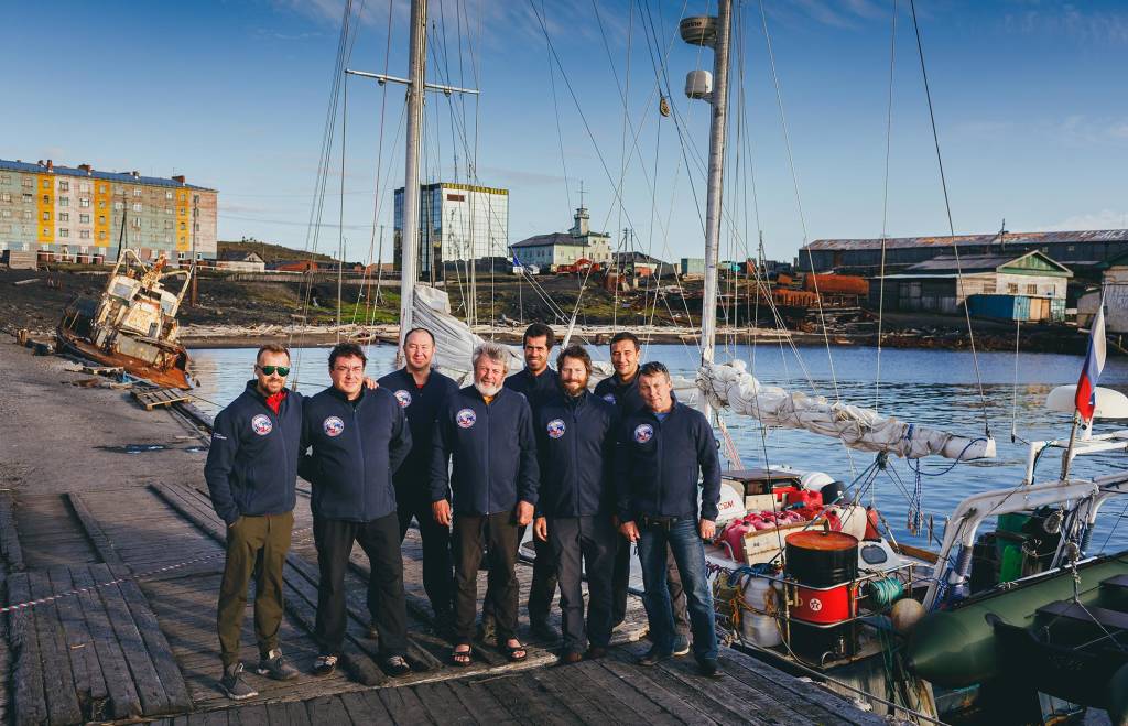
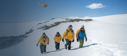
Solan Jensen (3rd from right) and his team of seasoned Arctic explorers prepare for their
exploratory journey to Severnaya Zemlya, the last territorial discovery in the world . Photo: David Merron
The team included our chief mate, Pavel, who’s been sailing since he was 7 years old and has the polar regions in his DNA. His grandfather taught and mentored at the Arctic and Antarctic Institute in St. Petersburg and was a member of the first Russian polar drift station. Alexander (Sasha to us) was our Polar Bear Guard and expert boatman who lives in the Russian Arctic and has traveled in Antarctica, was chosen for his relentless work ethic and expertise with firearms. Ruslan Esilev was the logistics kingpin and an incredibly skillful videographer/photographer—with the uncanny ability to instantly make friends with everyone he meets. Our operations-minded Expedition Surveyor David Allcorn, who’s best described as “pathologically positive,” divides his time between Arctic Canada and Antarctica. The Media Ambassador on this adventure was celebrated photographer and talented polar guide David Merron. Vladimir our expedition chef, was along for the adventure. He owns two restaurants in the Arctic city of Arkhangelsk which he happily leaves behind whenever Captain Litau calls on him for adventurous projects like this.
The gloriously endless light of an exotic land
Severnaya Zemlya possesses something exceptional that other Arctic destinations don’t: Severnaya Zemlya offers the mysterious aura of the exotic unknown. Few people have been here, minimal information is available, and on-the-ground visual depictions can rarely be found online.
Our first night at sea after leaving Dikson, a northern port on the Kara Sea at the mouth of the Yenisei Gulf, conditions were simply glorious. This part of Siberia’s northern coastal landscape is subdued, filled with sprawling lowland tundra. From the deck of the Apostol Andrey, the northern coast of Siberia looked like a thin shadow on the horizon as we sailed into the midnight sunset. Year to year the lowest extent of sea-ice varies yet usually occurs between late August and late September. At this point on our voyage we saw no ice, only the sea and a sliver of coast off the starboard side. We started with two watch-keeping cycles, the slightly unorthodox schedule 4 on, 4 off, 6 on, 6 off. The 20-hour cycle worked well in the context of the late polar summer, where the sunset gives way to civil twilight for a few hours and then rises again. We would basically operate in relative light 24 hours each day. The first sunrise was remarkable for its sheer duration. For hours the glow on the horizon just got bigger and bigger and brighter and brighter, finally to reveal the first beams.
We had to travel 400 nautical miles (740km) to reach Severnaya Zemlya. While it was our intention to visit a few islands in the Kara Sea en route to the archipelago, we didn’t plan to linger. After nearly three days of sailing and motoring we dropped the anchor off the South shore of Pravda Island in the Nordenskjold Archipelago, the site of an abandoned Soviet-era polar research and weather station. This would be our first exploratory landing of this journey.
Pravda Island, where we listened for ghosts and heard only wind
The rain had been falling throughout the day but it paused as we were preparing the small inflatable craft to go ashore. The station on Pravda Island was a scattering of buildings with wooden walkways barely elevated above the tundra, which at this time of year was soft and wet. Within minutes of arriving onshore, a strange feeling washed over us: we felt as if we’d been dropped off at on abandoned planet where a few humans were left to colonize. Visiting remains of long-abandoned human habitation in the Polar Regions can evoke this feeling—uncanny, strange and yet familiar.
The Arctic has figured into the global movement of humans for thousands of years. Further east in the Russian Arctic, 1,000 miles away in Novosibirskaya, Siberia, there are remains of a paleo-human Arctic village that are estimated to be 8,000 years old, as reported in Robert McGhee’s absolute must-read “The Last Imaginary Place: A Human History of the Arctic World.”
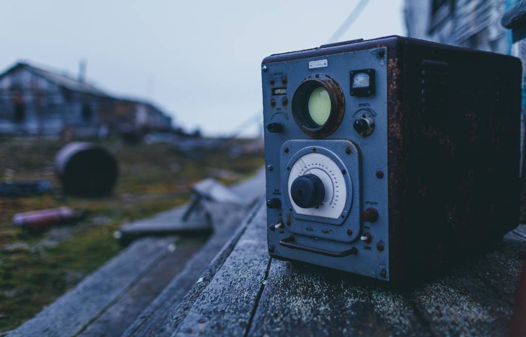
The remnants of human habitation at Pravda Station date back mere decades but felt much older. We witnessed the functionality and creativity of a once thriving remote polar station: a gigantic fuel tank that been re-fabricated into a plunge a pool (cut in half length wise, laid on its side and positioned adjacent to the doorway of the sauna-bathhouse); the machine shop; the infirmary; the commons with a large library featuring a chess board in the corner and rolls upon rolls of old film stock strewn across the floor. A short distance from the main building we spotted a four-storey lookout. At its foot lay a rusted wind gauge half absorbed into the tundra.
We listened for ghosts and heard only wind.
Upon arriving at Pravda Island, members of the team felt they had been dropped
off at an abandoned planet with no humans in sight. Photo: David Merron
Throughout the night we motored and sailed as favorable winds came and went. In the middle of the following day we approached our next island objective in the Nordenskjold Archipelago. Without any protection from the land, the wind was too strong for us to anchor and the waves too big to safely use the inflatable. Wind was forecasted to increase over the next day and a half. Attempting to cross Vylkitski Strait for Severnaya Zemlya in these conditions would be very slow and difficult. Captain Litau knew of a very well-protected anchorage a few hours’ sail to the southwhere we could overnight in calm conditions. We hoped the inlet would provide us a place to watch the storm peak and pass in relative protection.
The bay we reached was extremely well-protected. We enjoyed the stability onboard to get work done on the computer, such as editing photographs and sifting through drone footage. Meanwhile, the captain and I continued to discuss our plan A and plan B, C, D…. as we received updated ice charts and extended weather forecasts.
Our 36-hour journey through an Arctic gale
On the fourth day of our voyage we woke after a deep sleep in the shelter of Ostrov Pilota Makhotkina and headed into the storm. We were heading northbound, straight into the wind, which slowed our progress to 3-4 knots (approximately 6 to 7 kilometres per hour), as we experienced heavy pounding pitch.
The yacht was designed such that there was no cover protection from the elements when any of us stood at the helm. The trade-off meant there were relatively unobstructed views in every direction. The temperature was just above freezing, and the wind delivered a cold sea-water shower with every pitch of the boat.
The wind increased throughout the day. By early evening we had only progressed a short distance into the fierce open water of VylkitskyStrait. Then the wind started to change direction to the east, which prompted a rolling side-to-side movement. The sails were soon up and our speed instantly jumped to 6, 7, 8, 9 knots. We were charging through the waves. Hope at last!
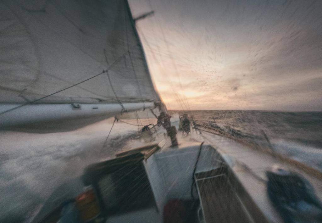
Crossing the Vilkitsky Strait. Photo: David Merron
Those of us who were not experienced sailors were tested—physically and mentally—each of us at different times. Just as the wind speed was near gale-force, and the vessel bucking like a wild stallion, I was in the depths of motion sickness unable to even dream of a way out. Just endure.
Chief Mate Pavel stood on the bench at the helm, reading every approaching wave, steering with economy, constantly searching for that perfect tack. Despite being showered in freezing cold water, he was utterly relaxed. After 36 hrs of pounding through an Arctic gale we found shelter on the leeward, the southwest side of OctoberRevolution Island, the largest island in the Severnaya Zemlya archipelago. It took us all some hours to put ourselves back together again.

Crew members (L-R) Solan Jensen, Captain Nicolay Litau and logistics kingpin Ruslan Esilev. Photo: David Merron
Eager to feel land under foot, our binoculars raised in the low-angle light, we identified two polar bears resting on the shore. We observed them from the deck of our vessel as they approached each other—touching noses, licking faces—and then separated again as they laid down on the tundra. Behind the bears, far beyond the low rolling hills, we mistakenly thought we spotted a distinct cloud line. Turns out it was actually the horizon line of the Lednik Universitetskiy (University Glacier), one of three huge glacial domes that cover half the island.

Polar bear sighting at University Glacier. Photo: David Merron
The icebergs, the clouds and the dimming light were magnified by the mirror-like waters of the calm bay. The forecast predicted ongoing northeasterly wind for the next day and half at least. We planned to stay on the protected side of the island so we could explore features of the west coast. As we searched for sites that offered good hiking and walking opportunities, we also surveyed plants, animals, topography, and potential landing sites. We were especially curious about the broad tongue of the Vavilov Glacial cap which appeared to protrude out in the sea.
We explored Marakova Bay, a micro-climate of polar desert where we saw lemming burrows, moss patches, struggling bits of vegetation and little else. The first distinct feature on shore was an old wooden marker, a tripod structure about 5 meters high, likely a navigational aid from the Soviet Era. The top layer of the permafrost, the active layer, was thawed out and soft under foot.
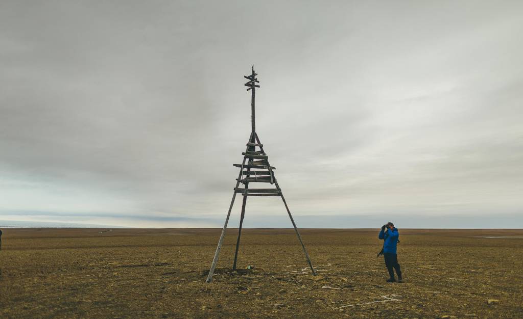
Upon landing at Marakova Bay, a crew member discovers an old wooden marker fashioned into a tripod, likely used
as a navigational aid during the Soviet Era. Photo: David Merron
On the evening of our seventh expedition day, we found ourselves further north at Krzhizhonovskyy Point, where we walked along the 1-km shore to the glacial edge. The land was completely covered in massive mats of moss and lichen that stretched in every direction. Completely different from the morning’s landing site. This too, was the first place we were able to view the red rivers of Severnaya Zemlya.
Where the red rivers flow
In the early 1930s a small Soviet team was sent to the archipelago to produce a detailed survey of the significant territorial discovery that was made almost two decades earlier. The team was small yet it was remarkable, including expedition leader Georgy Alexeyevich Ushakov; geologist and scientific lead N.N. Urvantzev; radio operator W.W. Khodov; and hunter S.J. Jouravlev. They spent two years exploring the islands, operating from their base camp on Domashnyy Island.

The team was excited to observe up close the mysterious “red rivers of Severnaya Zemlya”
at Krzhizhonovskyy Point. Photo: David Merron
They accomplished all of their objectives. In the geomorphological survey of the islands, Urvantzev identified areas of brick-red sandstone and clay which are believed to be the source of the Red Rivers of Severnaya Zemlya. The rivers are red due to the presence of iron oxide (hematite) swirling and mixing with the blue outwash from the glacier. This was a remarkable sight. The aerial views—thanks to the drones and their devoted pilots—granted us an unforgettable perspective.
This special 3-part blog series continues in Part 2 and concludes in Part 3.